Gilliams who received Land in Ohio
Updated November 25, 2025
Background:
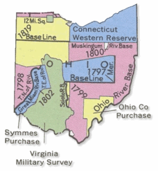
The Virginia Military District was an approximately 4.2 million acre (17,000 km²) area of land in what is now the state of Ohio that was reserved by Virginia to use as payment for veterans of the American Revolutionary War.
Virginia had historic claims to much of the Northwest Territory, which included Ohio, dating from its colonial charter. Virginia and the other states with claims over western lands had to cede those claims to overcome other states' objections to ratifying the Articles of Confederation. In return for ceding its claims in 1784, Virginia was granted this area to provide military bounty land grants. The Ohio district was a surplus reserve, in that military land grants were first made in an area southeast of the Ohio River, in what is now Kentucky. The Ohio land was to be used only after the land southeast of the river was exhausted.
The land was located in southern Ohio, bordered by the Ohio River on the south, the Little Miami River on the west, and the Scioto River on the east and the north. The District encompassed all of the following Ohio counties: Adams, Brown, Clinton, Clermont, Highland, Fayette, Madison and Union, and portions of these counties: Scioto, Pike, Ross, Pickaway, Franklin, Delaware, Marion, Hardin, Logan, Clark, Greene, Champaign. Warren, Hamilton and Auglaize.
The District was opened for settlement in 1794, although surveys had begun in the 1780s. Surveys were done using the metes and bounds method used in Virginia, rather than the Public Land Survey System established by the Land Ordinance of 1785 which was more used for the most of the Northwest Territory. The precise boundaries of the district was a subject of contention for many years, involving multiple acts of Congress and a Supreme Court decision (Doddridge vs. Thompson et al., 9 Wheaton, 469). Further complicating the matter was the imprecise location of the line established with the Treaty of Greenville, which separated Native American lands from lands open to white settlers and which ran through the northern portion of the District.
Virginia issued bounty land grants in this District until Ohio became a state in 1803. However, rampant land speculation and outright frauds produced a contentious muddle for many years afterward. Congress extended the time allowed for claims to be made several times. The last extension act was passed on March 3, 1855, allowing two years for claims made prior to January 1, 1852 to be surveyed and patented. After two years, unsurveyed lands became property of the United States. On February 18, 1871, this unsurveyed and unsold land was ceded by the federal government to the state of Ohio. In 1872, the Ohio legislature gave this land to the Ohio Agricultural and Mechanical College (now the Ohio State University). The college trustees aggressively claimed lands where there was not clear title, sometimes uprooting families who had been farming the land for 75 years. This caused such an uproar that Congress was forced to act and on May 27, 1880, passed legislation limiting the rights of the college to unappropriated lands. Some provisions of this legislation opened the doors to a new round of legal wrangling.
Massie's Station (now Manchester, Ohio), founded in 1791, was the first permanent settlement in the District, named after Nathaniel Massie, a surveyor and land speculator. He also founded Chillicothe, Ohio in 1796.
Many Virginians settled in the area, even though it meant giving up their slaves, due to the provisions of the Northwest Ordinance of 1787.
Virginia soldiers of the Continental line, who served in the Revolutionary War, were eligible to procure a bounty award in the form of land, according to a formula based on rank and time of service. The first step was to secure a proper certificate of actual service and to then acquire a printed warrant from the land office in Virginia specifying the quantity of land. This warrant empowered the person to whom it was given, or heirs and assignees, to select the specified area from anywhere within the military reserve district. After the location was chosen and boundaries surveyed, the owner of the warrant exchanged it for a patent, which was equivalent to a deed in fee simple and passed all title of the government to the holder.
Overview:
One such Revolutionary War veteran that received land in Ohio was John Gilliam of the Continental LIne. John was the son of HInchea Gilliam and Amy Briggs, his wife. John died 3 Dec 1776 at Portsmouth, VA. His Will dated 23 Sep 1776 refers to his brothers William and Hinchea. HInchea as heir at law lays claim to these lands.
Gilliams receiving Land in Ohio
Sorted by County
| Patentee Name | County | Issue Date | Acreage | Land Office |
| Gilliam, Hincha | | 14 Mar 1798 | 605 | Ohio |
| Gilliam, Hincha | | 14 Mar 1798 | 199 | Ohio |
| Gilliam, Hincha | | 14 Mar 1798 | 805 | Ohio |
| Gilliam, Hincha | | 14 Mar 1798 | 440 | Ohio |
| Gilliam, Hincha | | 14 Mar 1798 | 617 | Ohio |
| Gilham, Israel | Belmont | 20 Sep 1839 | 40.25 | Marietta |
| Gilham, Thomas | Belmont | 29 May 1914 | 152.85 | Steubenville |
| Gillum, Mary | Coshocton | 10 Apr 1837 | 40 | Zanesville |
| Gillam, Jonathan | Franklin | 19 Nov 1931 | 232.16 | Cincinnati |
| Gilliaen, James B | Gallia | 1 Aug 1848 | 40.36 | Chillicothe |
| Gillam, Hartwell | Henry | 10 May 1854 | 40 | Defiance |
| Gillam, William | Holmes | 25 Feb 1836 | 80 | Wooster |
| Gillen, William | Lawrence | 25 Nov 1835 | 40.35 | Chillicothe |
| Gillam, Nancy | Muskingum | 30 Apr 835 | 81.08 | Zanesville |
| Gillam, Nancy | Muskingum | 30 Apr 1835 | 81.13 | Zanesville |
| Gillam, Hartwell | Paulding | 22 Apr 1853 | 40 | Defiance |
| Gillan, Madison | Pike | 20 Mar 1878 | 22.25 | Chillicothe |
| Gilliam, Grover | Randolph | 7 Nov 1837 | 80 | Cincinnati |
| Gilliam, Hiram | Randolph | 7 Nov 1837 | 160 | Cincinnati |
| Gillum, Thomas | Randolph | 14 Aug 1834 | 80 | Cincinnati |
| Gillum, Thomas | Randolph | 16 Oct 1835 | 86.16 | Cincinnati |
| Gillum, Thomas | Randolph | 16 Oct 1835 | 40 | Cincinnati |
| Gillum, Thomas | Randolph | 16 Oct 1835 | 40 | Cincinnati |
| Gillum, Thomas | Randolph | 7 Nov 1837 | 120.48 | Cincinnati |
Sources
- Bureau of Land Management, General Land Office Records. www.glorecords.blm.gov/